Field surveillance
UAV TAKES SCOUTING TO A HIGHER LEVEL
THOMPSONS IS TAKING precision agriculture to new heights with an aerial scouting drone that was launched this year. E.A.R.L. – an acronym for Enhanced Aerial Reconnaissance Land-surveyor – is an unmanned aircraft that the company can use to fly over a farmer’s field.

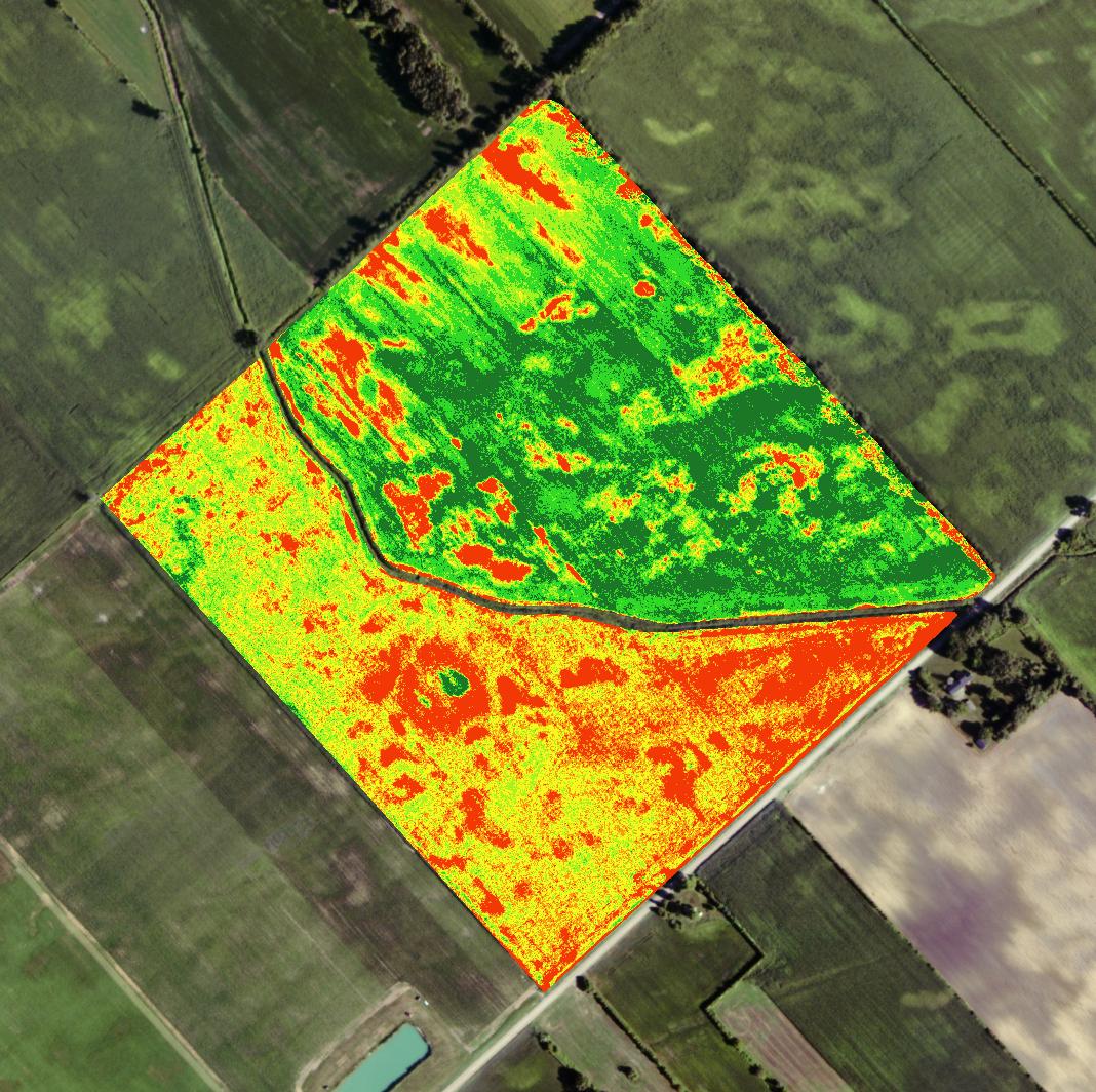
PHOTO: In the aerial image of Frank Furlan’s farm (below), the red and yellow areas in the southwest section are in a corn field that has not been growing as rapidly as the soybean field in the northeast section. The line through the middle is a ditch that separates the two fields.
Mike Wilson of Thompsons says the areas affected from the early water damage and the sand hills affected from the dry weather later in the season show up in red areas, and the higher growth or good areas are darkest green.
“It’s got a camera mounted on the bottom of it and we can fly it over the field to take some pictures to see the severity of damage, the growth of the crop or whatever the customer is asking us to take a look at,” says Mike Wilson, Assistant Manager of the Kent Bridge branch of Thompsons.
ADVANCED IMAGERY
Aerial imagery has several practical uses such as scouting areas that have been stressed from weeds, insects, disease or nutrient deficiency. It can also help identify areas that need drainage improvement, monitor the performance of fungicide or fertilizer applications, and create zones for soil testing.
“Precision farming is all about data collection and the more layers you can get to answer specific problems, the clearer it becomes,” says Wilson of the aerial imagery. “So this tool fits in perfectly with the goals of our customers and where we want to take our production levels. It gives them the data they need on the crops that don’t have yield potential.”
By combining a normal picture with an infrared image, the software creates an NDVI – Normalized Difference Vegetation Index – to measure the greenness of the plants, indicating the condition of the crops. Dark green images represent good crop health, whereas red images show problem areas.
NEW TECHNOLOGY
Wilson says Thompsons chose the compact Aeryon Scout Micro-UAV(unmanned aerial vehicle) for its rugged four-rotor design. “This one has four helicopter blades and we can fly it in stronger winds,” he notes. “The camera is on a gyroscope and compensates for some shifts.”
Equipped with GPS navigation, the UAV is controlled by a touch-screen tablet after a flight plan has been set. Thompsons charges a fee of about $5.00 an acre per flight.
Wilson says the opportunity to see a field from above at 1,000 feet offers a different perspective. It can show patterns and issues that people may not realize are in the field. In addition, he says it adds an important piece of information.
“With all the new technology that comes with the new monitors and data collection, whether it’s in a planter, combine or the fertilizer truck that’s coming to spread your variable rate fertilizer, it can only do as good a job as the information you put into it,” advises Wilson. “If you don’t have the right data layer for the truck to read that matches the customer’s goals, then it’s not going to do the job he’s looking for.”
FIELD APPLICATION
Frank Furlan, who farms in the Kent Bridge area, uses the aerial imagery to enhance the soil sampling of his fields and fine-tune his variable-rate program for applying phosphorous, potash and micro-nutrients.
Furlan says the images make it easier for people taking soil samples to find the problem spots in the field and get more accurate readings. “Compared to when we used to simply just grid-sample, I think this technology is one leg up from that,” notes Furlan. “This is a little more accurate for variable-rate fertilization. I’m trying to get each acre to be more efficient; that’s what the goal is.”
With images of the field taken in late July or early August, Furlan uses the photos to locate the weaker spots and investigate them for potential problems for the next crop. “Let’s see why and take samples from that and see if it’s missing anything,” says Furlan. “Then those areas are picked up with the variable-rate truck and spread according to soil samples. I want to know what’s out there and ahead of me, especially on variable-type soils.”
While Furlan says it is too early to judge the payback on aerial imagery, he adds that it has been a welcome addition to his precision ag system. “I just assume it has to work. It is definitely applying the fertilizer where it needs it the most,” says Furlan. •


