Understanding precision agriculture
AN INTRODUCTION TO MANAGEMENT ZONES
THIS ARTICLE IS the first of a series intended to introduce and explain the concept of management zones, to provide a process to define, delineate, and characterize management zones, and to outline the kinds of data and computer tools needed to be successful.

Many Ontario producers are using precision agriculture technologies — RTK GPS for guidance, precision planters, yield monitors, software, and “as applied maps”, for example. Precision agriculture is capable of generating vast amounts of data in the form of yield data, maps, and soil fertility, among others. There is a growing desire for precision software toolkits that will assist producers in converting data into useful knowledge that will help in their decision making. It is not unusual for growers to remark, “I have lots of data, but I don’t know what to do with it.”
The concept of the management zone is best described by Joe Berry, a professor at Colorado State University, who says, “at the heart of precision farming lies site-specific management, which involves the ability to collect and control information to accurately and appropriately address parts of fields for actual needs, rather than whole fields for average needs.”
The ‘parts of fields’ described by Berry are commonly called management zones. Management zones are areas within a field that have similar yield potential based on soil type, slope position, soil chemistry, microclimate, and/or other factors that influence crop production. The producer’s knowledge of a field is a very important piece of the process. Management zones are thought of as a mechanism to optimize crop inputs and yield potential.
INTEGRATION
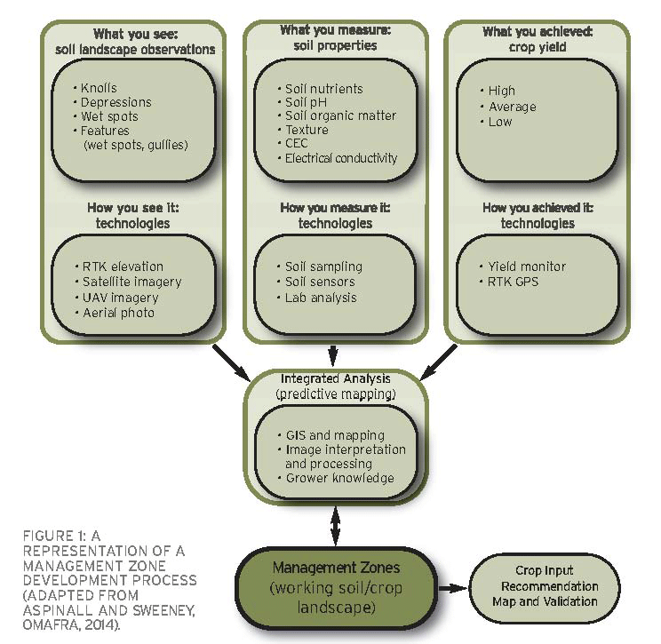
The process of defining, delineating, and characterizing management zones is outlined in Figure 1. They are the result of an integration of soils, landscape factors, and crop performance measures. Subsequent articles will explore each of these components in greater detail. The development of the data layers and their integration is achieved by using a set of computer tools. Examples of precision agriculture computer tools are SMS and Farm Works. One outcome of a current research project being conducted by the Ontario Ministry of Agriculture, Food and Rural Affairs (OMAFRA) with Grain Farmers of Ontario (see sidebar) is the development of an automated data processing tool by Niagara College. It will take in raw data, process it, create data layers, and perform an integration analysis to produce management zone maps for individual farm fields.
FIGURE 1: A REPRESENTATION OF A MANAGEMENT ZONE DEVELOPMENT PROCESS (ADAPTED FROM ASPINALL AND SWEENEY, OMAFRA, 2014).
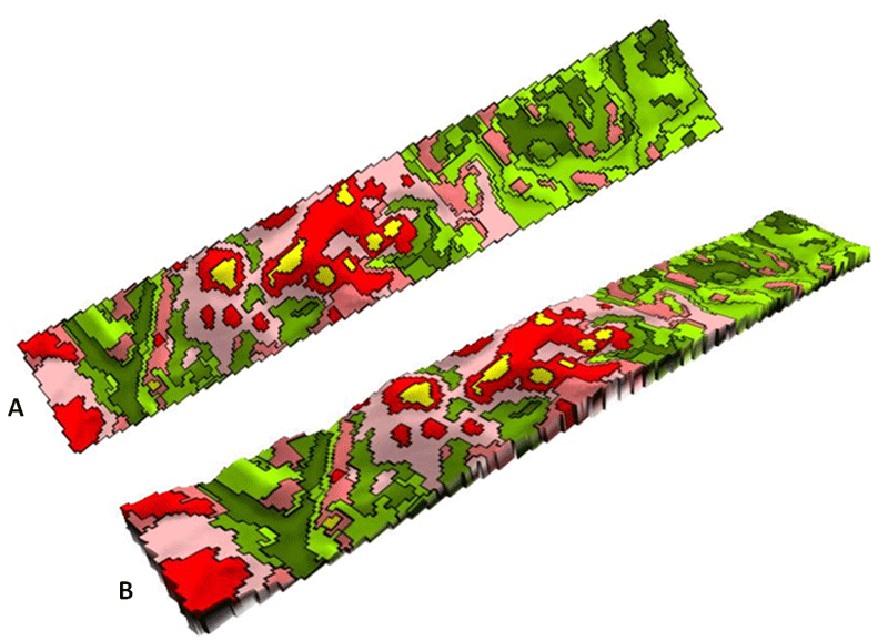
An example of a management zone map for a field located in Middlesex County, Ontario is given in Figure 2. Map A is a two-dimensional representation of the zones. Map B is Map A draped over a three-dimensional surface created from an elevation data set. A three- dimensional map provides a better visualization of the positioning and relationships of the zones to one another and to the landscape. Data inputs for this map included RTK GPS elevation data, six years of corn yield monitor data, and several soil point samples analyzed for texture, organic matter percentage, and pH. Based on the data processed, eight zones were created on this map and each zone is a unique combination of yield performance, CEC, and pH. The CEC map is a combination of maps showing the percentage of clay and the percentage of organic matter. Predictive soil mapping tools were used to generate the soil property maps.
FIGURE 2: MANAGEMENT ZONE MAPS GENERATED BY THE INTEGRATION OF YIELD, ELEVATION AND SOILS DATA. COURTESY DOUG ASPINALL.
LAYERS
Zones can be characterized by the data input layers used to define them. Figure 2 shows, in general terms, the green zones have above average yields (the darker the green the higher the yield). Red and yellow zones are below average yielding and tend to be on the sandy soils portions of the field. The consistently lowest yielding areas of the field are found in the yellow zones.
More specifically, the dark green zones on the map have very high and stable yields (high yields every year), a high percentage of organic matter, high soil moisture, are a loamy soil texture, have a high pH and a high CEC, and are found in the low ground or depression areas of the field. In other words, the dark green zones are the most productive areas of the field.
The yellow zones are very much the opposite. They have very low but stable yields (poor yields every year), a lower percentage of organic matter, lower soil moisture, very low pH values, low CEC, are a sandy soil texture, have nutrient deficiency symptoms, and are found on the tops of high knolls.
Zones are considered to be more or less permanent and can be used as a foundation for building application or prescription maps. For example, the zone map could be used to devise a zone soil sampling strategy. The results of the sampling could be combined with the zone map to create a potassium ppm map for the field. In turn, the ppm map could be transformed into an application map that is loaded into field equipment.
Future articles in this series will explore the three pillars of the management zone definition outlined in Figure 1, why they are important, and how they fit within the integrated analysis step in the pursuit of high resolution management zones. The final article will relate the layers together to support the comments made in this article. It will explore the methodology needed to assign prescriptions to the various management zones within a field and validate whether the decisions were correct.
PRECISION AGRICULTURE ADVANCEMENT IN ONTARIO
In 2013, Grain Farmers of Ontario and the Ontario Ministry of Agriculture, Food and Rural Affairs (OMAFRA) met with a number of farm service companies to discuss what obstacles exist for farmers trying to get started with precision agriculture techniques. The group pulled together a list of research topics that would benefit farmers and consultants in Ontario and committed to a collaborative effort to identify repeatable best practices related to data collection, data usage, management zone definitions, deployment of site specific input prescriptions, and defining the tangible benefits of precision agriculture.
The four year project assembles expertise from OMAFRA, Niagara College, farm consultants, equipment retailers, and farmers for a full cross- section of industry and research knowledge with interests in this area. The research team will develop a protocol for collecting field variables and creating digital layers of farm fields, towards defining management zones within the field. With stable management zones, crop inputs can be matched to yield potential across a field. A computer infrastructure (“portal”) that can house and process all of these various data layers will be constructed, which will render data into digitized maps that will be compared and contrasted. Researchers will also develop methods for farmers to validate precision agriculture practices on their farm.
This project is funded in part through Growing Forward 2, a federal-provincial-territorial initiative. The Agricultural Adaptation Council assists in the delivery of Growing Forward 2 in Ontario. •