Field data
NEW SOIL ANALYSIS TECHNOLOGY
“IN THE UNITED STATES, when you go to meetings, farmers talk about their farms by their soil types,” explains Greg Kitching, integrated solutions consultant at Premier Equipment in Elmira, ON. Kitching, also a certified crop advisor (CCA), has been interested in large-scale agronomic data collection for decades; more recently, with the help of new software by Trimble. In Ontario, Kitching admits, “we don’t have historical soil data that is as good as Americans do.”

Farmers know a lot about their land, but he says we generally do not know much past the top six inches. This is especially the case for larger operations growing crops on land they rent which doesn’t usually provide them access to a lot of comprehensive historical data. It is also a concern on newly purchased land that they have not had the opportunity to work for very long.
Kitching, along with the rest of Premier’s Integrated Solutions team, wants to help alleviate some of that risk through the use of new technology and a lot of math.
Agronomy is partially a decision science; through research and observation, and constantly evolving tools and techniques, we learn how to make decisions about our land and our crops. Farmers have always collected data. Within the last decade, it has become possible to collect data sets so large and complex that traditional measurement and analysis methodologies have become obsolete — the challenge is not gathering information so much as it is making sense of it.
The agriculture industry has taken notice, and a number of companies — like the Trimble Connected Farm platform and John Deere’s My John Deere web portal — are working to harness the power of big data to make agronomic decisions.
IN THE FIELD
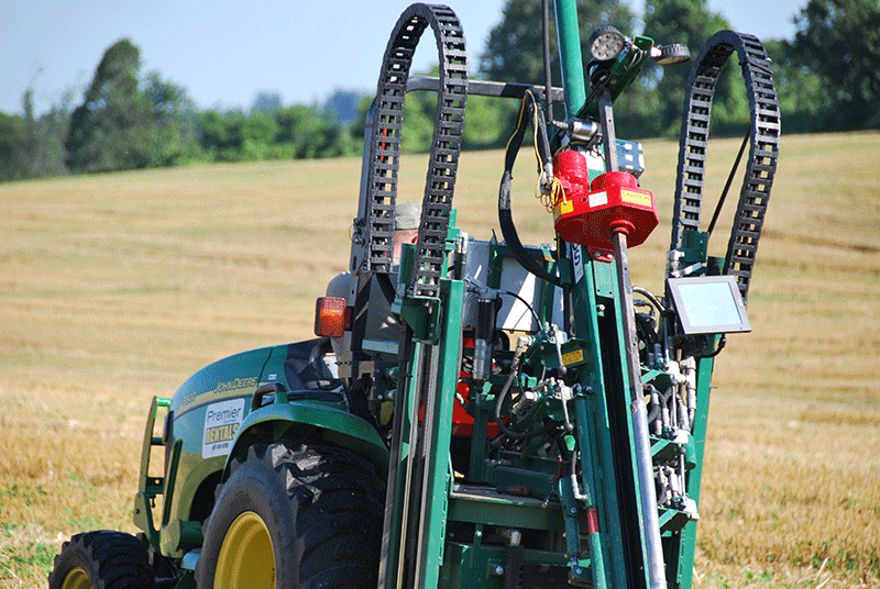
One Thursday in early August, Ontario Grain Farmer magazine joined Kitching, his colleague Kaye McLagan, and a soil sampling rig in a freshly-harvested wheat field just east of Guelph. When work started the day before, Kitching and McLagan created a digital map of the field using one of Premier’s fleet of John Deere Gators and an electromagnetic (EM) sensor rig built by Milton, Ontario’s DualEM.
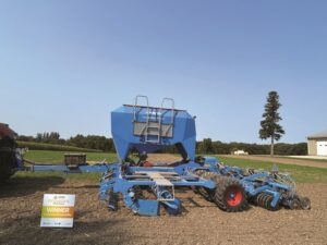
Kitching uses the EM map to determine where he needs to take physical soil samples. On this roughly 66 acre field, he used GPS to mark drilling points at a ten-metre resolution (in the past, he has sampled fields at as small as one-metre resolution).
The soil sampling rig, mounted on the back of a John Deere 3520, is made by Giddings in Colorado. The specialized probe is made in Vermont by a company called Vertek. All of the equipment constantly streams data to software made by Trimble.
The software, which uses the data to output an interactive soil map, is what Kitching credits as the key to this process. “We were already using all of this equipment and we were already capable of measuring this, but we didn’t know what to do with it in a comprehensive way. The algorithms, made by Dr. Daniel Rooney, Trimble’s stategic development manager, are what make
it special.”
The sophistication and quality of the output of the product is why Kitching is proud that Premier Equipment is the only operator in Ontario.
QUALITY INFORMATION
The difference between an EM map, which is relatively easy to build with a sensor like the DualEM one Kitching uses, and Trimble’s soil maps is the quality of information. An EM sensor does not measure the soil itself; it registers the rate a current travels through it. Trimble has found that an EM map will often show the same reading in different parts of a field, across a variety of different soil property types. While EM is an excellent tool, it is limited because it is only one variable. Trimble’s system weighs EM data against other types of data collected to build a more complete soil map.
Kitching collects this additional data with the Vertek probe — an expensive, sensitive piece of equipment that needs annual calibration and servicing in the United States. While drilling at a depth of four feet, it measures tip pressure, sleeve pressure, moisture content, and electrical conductivity. The pressure along the sleeve of the probe correlates to the texture of the soil, while the pressure on the tip correlates to soil compaction.
“We think of compaction, especially, as something we’ve done to the soil by driving on it or using equipment. But there is a natural relationship between compaction and texture, which is important,” says Kitching.
Electrical conductivity is an increasingly popular method of determining nutrient management zones.
“The process maps variability in the field,” says Kitching. Using the soil map, one can identify areas that are severely compacted, and would therefore likely need mechanical tillage. Especially in a field with some known problem areas, a farmer can save man hours and diesel by tilling only where he needs to, and using a cover crop for the rest of the field.
FUTURE APPLICATIONS
In the future, Kitching believes that it will be possible for precision equipment to make tillage depth adjustments on the fly, based on GIS information from soil maps like these. “Most new systems are already tracking things like tillage depth and streaming it to programs like My John Deere; in the future it could be pretty easy to program these types of directions based on GPS.”
Kitching believes the hydrology data he is able to collect with this system is the most useful and most often overlooked aspect. He sees future drainage and irrigation design opportunities; the team has already used one of their soil maps for a drainage survey. The software is already able to output a nutrient capacity map for application management, based on moisture and conductivity measurements, and Kitching hopes that it can be used to more accurately document phosphorus levels at a high resolution.
“Economically and environmentally, it would be win-win,” he says about the potential for using this system to manage nutrient stewardship issues as they relate to water quality.
Also important not to overlook is the way he is able to share data from this system. As with any other decision-making tool, soil maps are only as good as the relationship between the farmer and his agronomist. Portals like this one allow trusted advisors up-to-the-minute access to farmers’ field data, and that free flow of information is what really makes this product so useful. •