Understanding precision agriculture
SOIL DATA
THIS ARTICLE IS the fourth in a series intended to introduce and explain the concept of management zones, to provide a process to define, delineate, and characterize management zones, and to outline the kinds of data and computer tools needed to be successful (go to www.gfo.ca/research/precisionag to read previous articles you may have missed).

In this article we will focus on creating a soil sampling strategy using yield, landscape, and soil maps. A surface soil texture map was prepared specifically for this article. A future article will discuss a process for creating detailed soil type and soil property maps. Yield and landscape component maps were discussed in previous articles.
Zones that have been created from yield and landscape information may have to be further subdivided if there are different yield limiting factors affecting performance. For example, a field may contain consistently low yielding areas that are made up of sandy and clay soils. The yield limiting factors affecting the sandy soils may have to do with low pH, a low percentage of organic matter(OM), thin topsoil depth, lower available water holding capacity (droughty soil), low cation exchange capacity (CEC), and perhaps fewer nutrients; and the yield limiting factors in the clay soils may be related to excess water, poor soil structure, and compaction. Soil information can be used to further partition or confirm management zones so that unique strategies can be devised and implemented for dealing with high and low yielding areas.
Exploring the soils in a field more fully helps to determine what makes each management zone unique. Without knowing these differences, you can not exploit the different management opportunities which are the heart of site specific management in precision agriculture
SOIL TYPE VS. SOIL PROPERTY
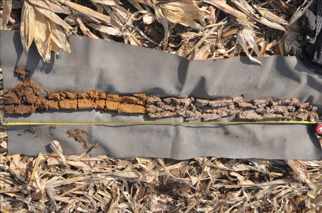
Soil type mapping requires the extraction of soil profiles using a coring device or an auger to a depth of about one meter. A soil type consists of a soil series name and a surface texture. The kinds and arrangement of soil horizons, as well as the parent material, are used to classify the soil series name. An example of the Bookton fine sandy loam soil type is shown in Figure 1. Visit the Agriculture Information Atlas (www.ontario.ca/ agmaps) to find out which soil types may exist in your fields. Surface soil properties that are of interest for management zone creation include per cent OM, topsoil thickness, pH, soil texture (for example clay loam, fine sandy loam), available water holding capacity (AWHC), CEC, bulk density, stoniness, and various nutrient levels.
SOIL SAMPLING
Soil information is required for defining, refining, and characterizing zones and for crafting application maps. The methodology used for making the maps requires the use of directed sampling. Directed sampling is a process of selecting a small number of representative yield, landscape, and soil combinations that will provide the most information and have the greatest impact on the development of soil knowledge.
FIGURE 2A: CORN, YIELD INDEX MAP FROM 7 YEARS OF YIELD MONITOR DATA
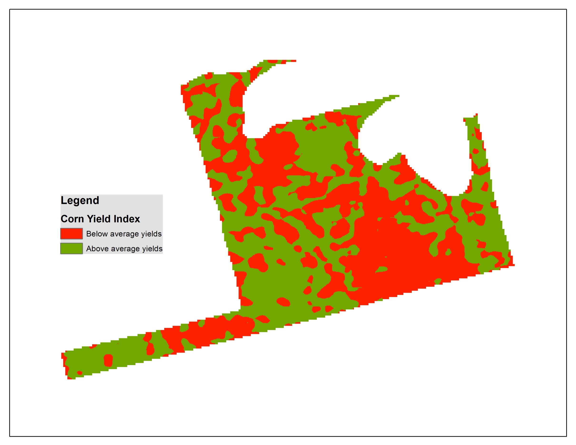
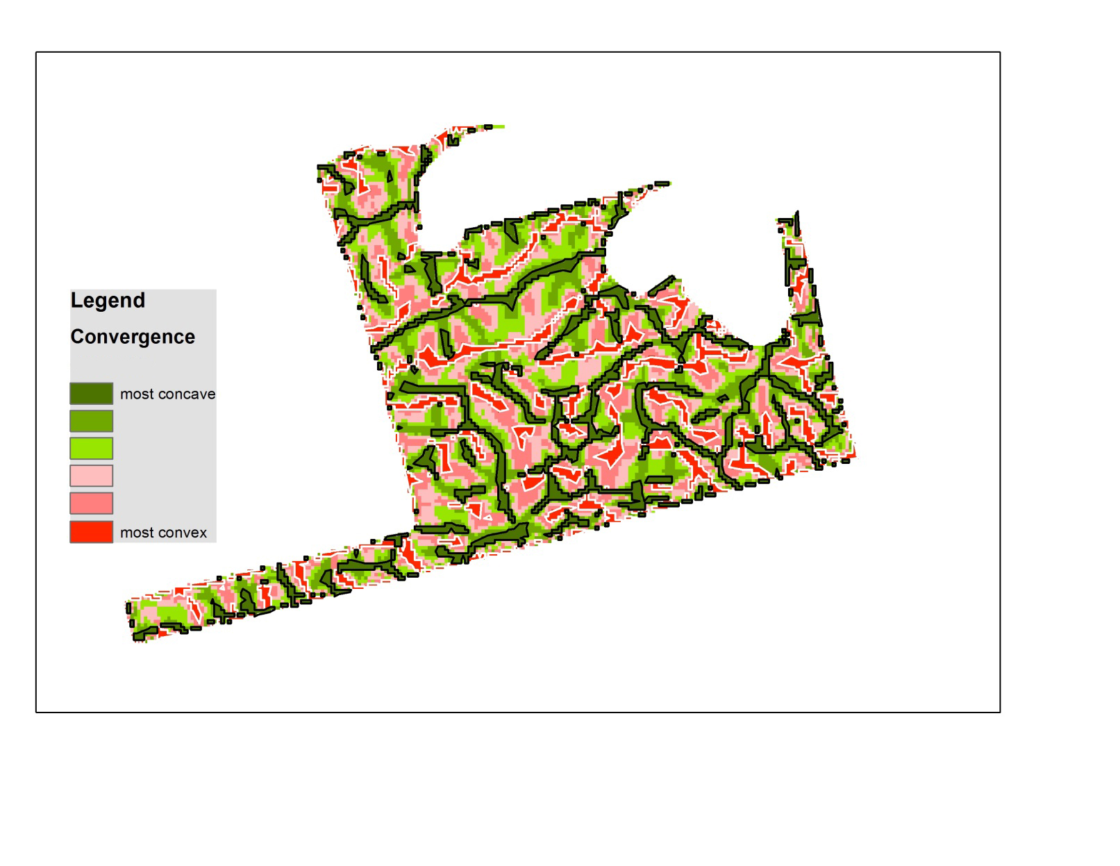
FIGURE 2B: CURVATURE MAP CREATED FROM ELEVATION DATA
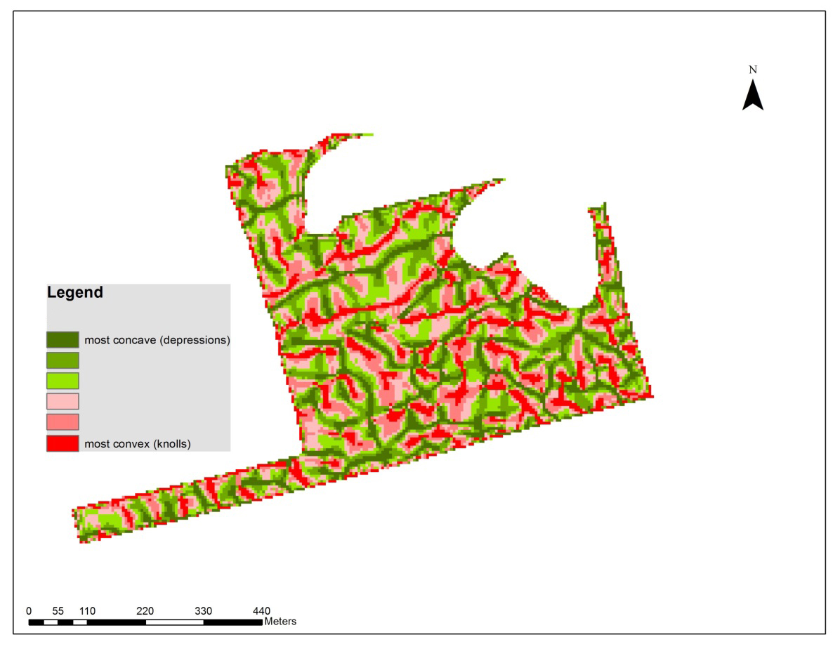
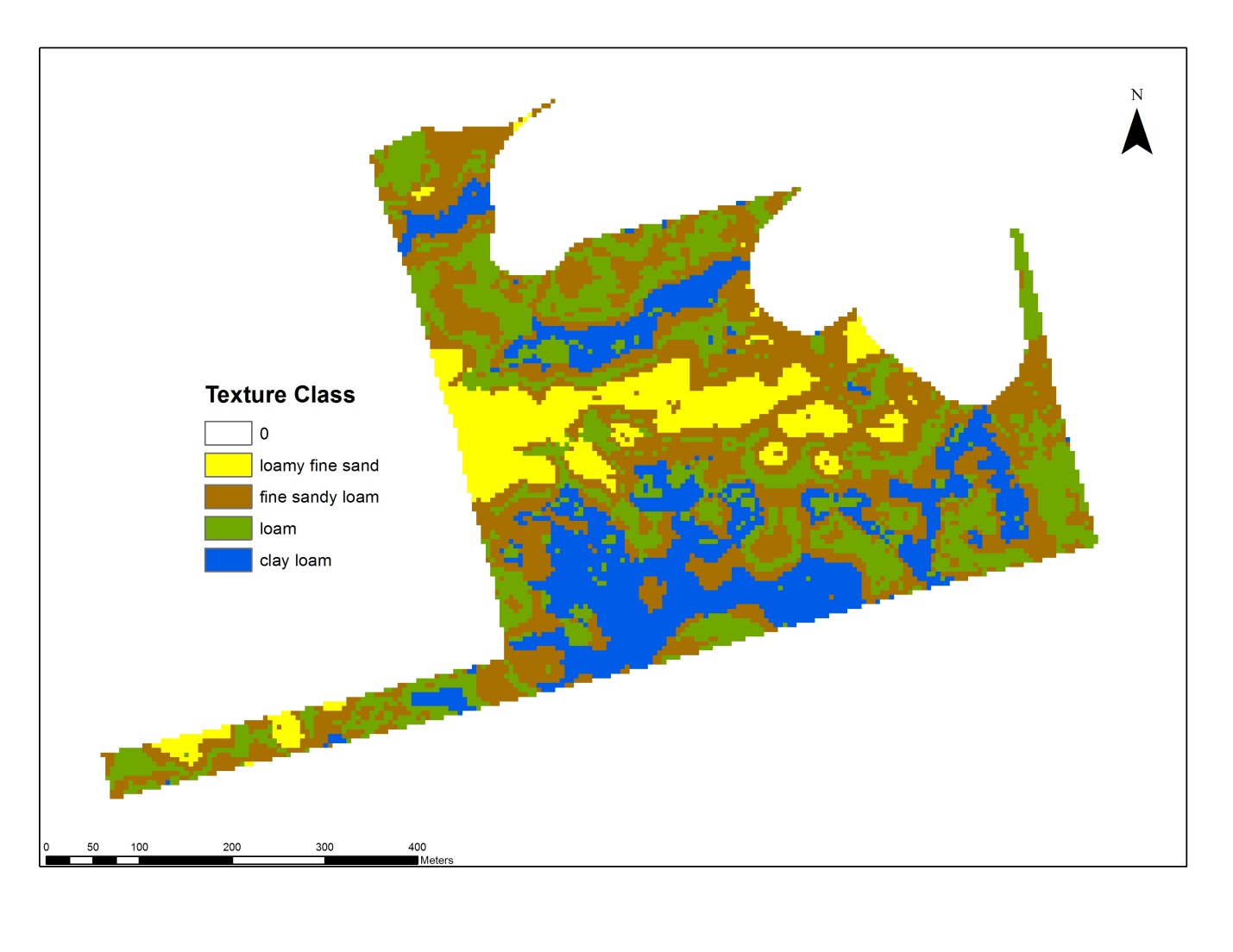
FIGURE 2C: SPATIAL VARIATION IN SOIL TEXTURE ACROSS THE FIELD
A significant financial investment is required for targeted soil sampling to collect soil property data for the purposes of defining and characterizing management zones; however, it is only collected at this intensity once.
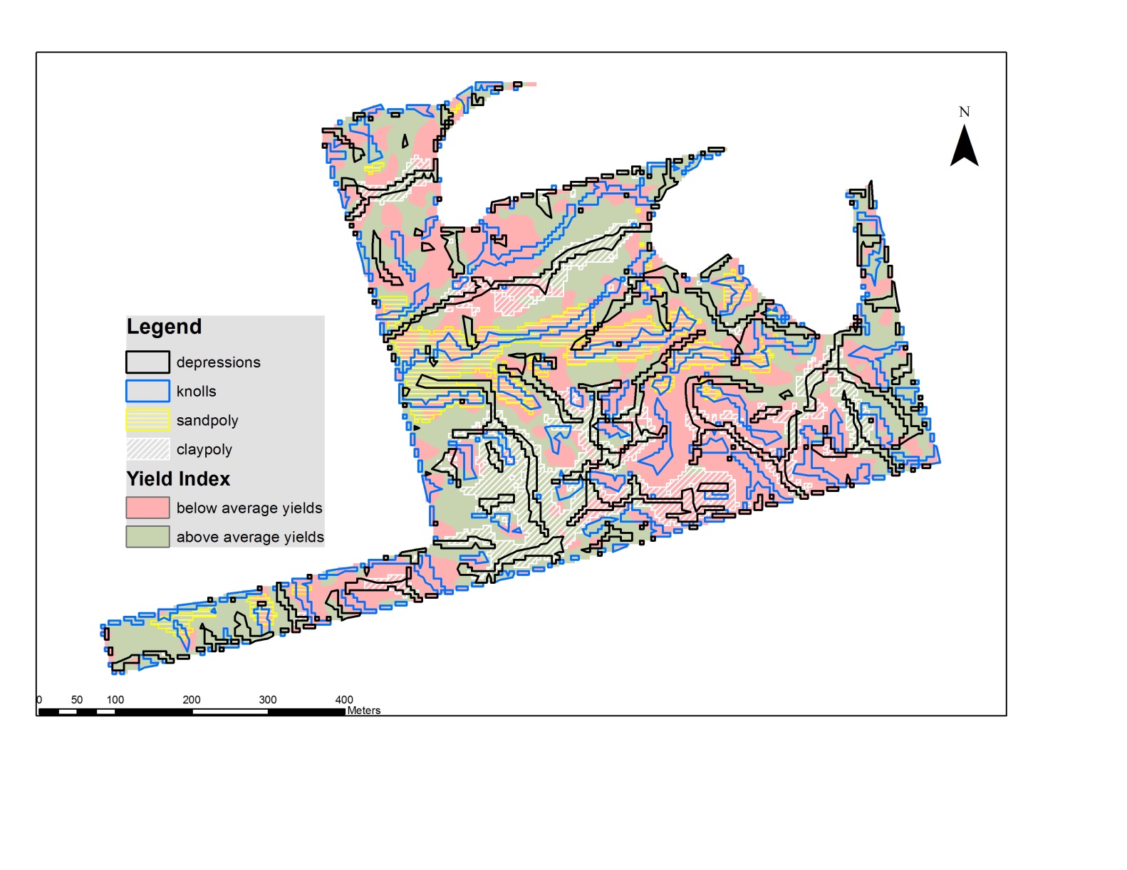
Following is an approach that could be used for picking sampling points in a field. For this example, three maps (Figure 2) are required to begin the process: a yield index map (Figure 2A), a concave/convexity map (Figure 2B), and a plow layer soil texture map (Figure 2C). The yield index map was made from seven years of corn yield monitor data. It shows where yields are either above or below average. The second map (Figure 2B) was extracted from a digital elevation model and shows where the land surface is concave (green) or convex (red). The third map shows the distribution of surface soil texture classes (the next article will discuss how this map was made).
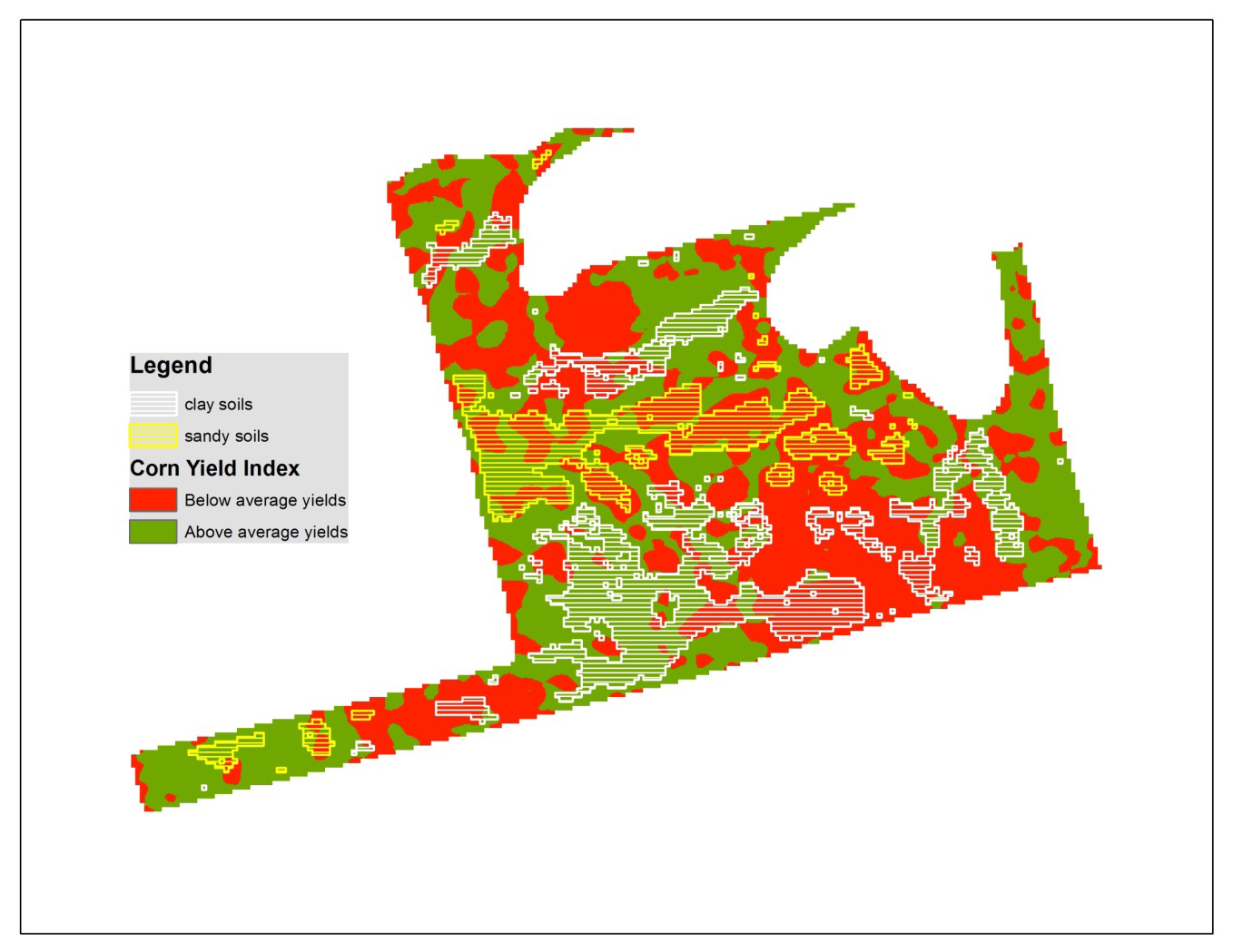
The second step of the process is to overlay the soil textures on the yield index map (Figure 3). In Figure 3 only the sandy and clay soils are shown.
Here it becomes evident that zones of above and below average yields occur on both sandy and clay soils.
FIGURE 3.
The next step is to create the landscape components to be used in the sample selection process. In Figure 4 the most concave (dark green) and convex parts (red) of the field have been selected. The red areas represent the tops of knolls and the green areas are the bottoms of depressions.
FIGURE 4.
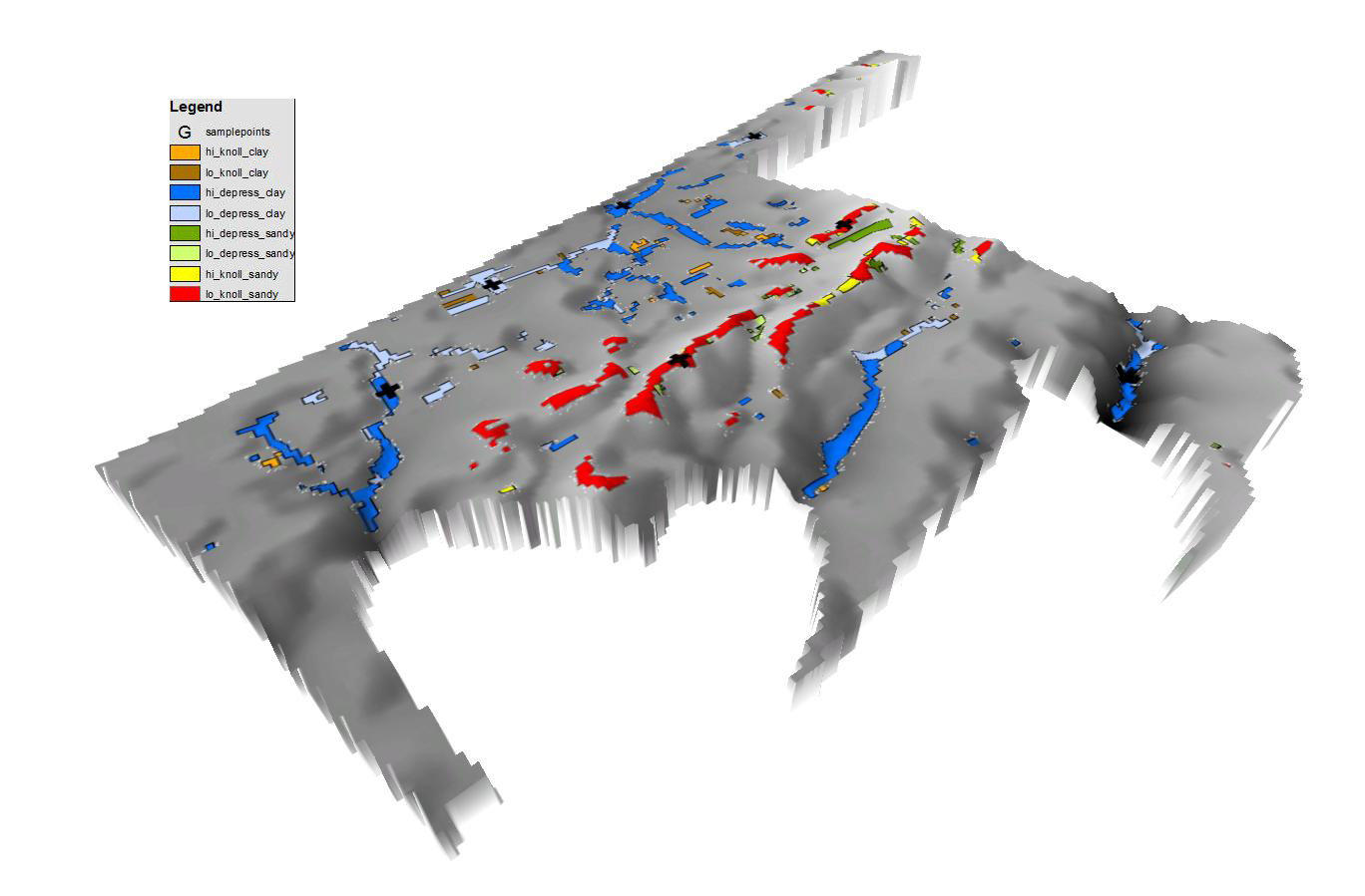
To create potential sampling areas in which sample points could be selected, the yield zones, soil zones, and landscape zones are intersected with one another. The intersection results in unique combinations of yield, landscape, and soil (Figure 5).
FIGURE 5.
For example, a black polygon on white diagonal lines on green yield zone is a high yielding clay soil located in a depression. A blue polygon on yellow diagonal lines on a red yield zone is equivalent to a low yielding sandy soil located on a knoll.
These unique combinations can be extracted and plotted individually (Figure 6). In the legend, the class “hi_knoll_clay” means a sample zone that has above average yields on a clay knoll. The large black crosses indicate potential sampling points. As indicated in Figure 2C there were four texture classes identified in this field. The same analysis approach could be applied to them and mid- slope areas as well. The sampling results, in turn, can be used to generate maps of soil properties or nutrients.
FIGURE 6.
SAMPLING TIPS
The number of composite samples required to characterize a field depends on zone size, topography, and the variability of soils within the field. Problem areas should be sampled separately to diagnose whether nutrient deficiencies are causing reduced crop growth.
Navigate to the sample points with a GPS. Collect a high quality composite sample by taking four to six cores 15 cm deep within a one to two metre radius of the sample point. The cores should be taken in the most prevalent soil within the sample area. If sampling for texture analysis, take some additional cores to make sure there is enough to sample. Try to avoid mixing subsoil with the topsoil. It is recommended to collect some additional information while at the sample point:
• GPS coordinates
• Depth of the A horizon of the soil, topsoil colour
• How much surface stone is present
• Slope position (top of knoll, depression), slope (steep, level etc.)
• A rough assessment of the surface soil texture: sandy, loamy, clay, crusting
• Crop vigour, emergence, population, crop colour
The GPS coordinates are required for any future predictive mapping of soil properties. The remaining field collected data will help you understand the uniquemess of the zones and the differing ability of the soils to support the crop you are growing.
The soil samples should be submitted to an accredited Ontario laboratory. Chemical analysis should include the typical fertility package (including pH, OM, P, K, Mg, Ca, Zn, Mn, CEC). Additional tests required for soil property mapping and characterization of the zones would include a texture analysis and a carbon package. A texture analysis includes a measure of the percent sand, silt, clay, gravel, and the amounts of coarse, medium, fine, and very fine sand. The laboratory should perform the texture analysis using the hydrometer method. The carbon package measures the amount of total carbon, organic, and inorganic carbon.
Unless you have significant erosion, texture remains stable over time and this sample only needs to be done once. However, soil sampling of the identified management zones needs to be conducted on a routine basis to understand the changes in nutrients, OM, pH, and other factors influenced by cropping methods and weather. This is often done on a three-year basis at the same point in crop rotation. Where large amounts of a single nutrient (such as K) are removed from sandy soils (particularly when used for high yielding alfalfa or corn silage), levels can change quickly and samples should be taken more frequently.
In the next article, we will cover a case study of how to use the tools we have been discussing to build predictive digital soil maps which is the next step in understanding site specific management within the overall concept of precision agriculture. •