Understanding precision agriculture
MANAGEMENT ZONE DEVELOPMENT PROCESS HIGHLIGHTS
THIS ARTICLE RECAPS the first six articles in a series intended to introduce and explain the concept of management zones, to provide a process to define, delineate, and characterize management zones, and to outline the kinds of data and computer tools needed to be successful (go to www.gfo.ca/research/precisionag to read previous articles you may have missed).

MANAGEMENT ZONES
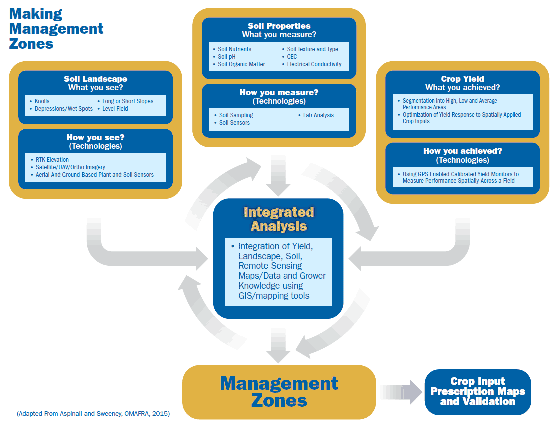
The focus of the first article, ‘An introduction to management zones’ explained the concept of integrating several data layers to achieve the most stable and reliable management zones which accurately define crop productivity potential across the landscape over time. Using any single data layer (Figure 1) may mask the underlying reasons for variable crop response across a field. Zones in a field may yield the same, but the reason for the similarity may vary due to soil properties, elevation, and other factors and thus should be managed differently. However, with different options for data layers, you are not hindered from starting to use precision agriculture if you don’t have all of the information possible (such as yield data on a newly rented farm).
MULTI-YEAR DATA
The second article, ‘The importance of multi-year yield data’, placed the emphasis on the information one might have from mining the data and normalizing historical GPS enabled yield information that has been collected but not utilized. The power of multi-year yield analysis is the ability to look at each year and crop individually. These yield stability maps do not look at absolute yield. They examine the stability of crop yield over time to determine which parts of fields are consistently high versus low production areas. Examining yield patterns or zones by crop type shows the impact of landscape, soil properties, climate, and other factors on each crop but not how or why they impact it. All data years can be viewed together in a yield stability map.
MAPPING AND MODELLING
The next article, ‘Mapping elevation and topographic modelling’, focused on how to collect good elevation data and turn that data into terrain layers which characterize the soil landscape. At a bare minimum, elevation data allows viewing all other data layers in 3D which is very beneficial in understanding why management zones exist. Post-processing the elevation data into a series of terrain layers is powerful in understanding why the crop responds differently in each zone. For example, the curvature and slope maps show how water flows differently across the field helping to identify areas of high (depressions) and low (knolls) yield potential.
SOIL DATA AND SOIL TYPE
Articles four, ‘Soil data, and five, ‘Soil type mapping’, explored the impact of soil on crop productivity. Determining the physical, chemical, and biological characteristics of the soils by depth within a zone can be used to create digital soil maps that help to identify why a crop performs differently across management zones. Some of the required mapping for creating better soil maps may involve more effort and investment than typical agronomic soil sampling practices but only has to be done once if completed correctly.
REMOTE SENSING
In the sixth article, ‘Remote Sensing’, both plant and soil sensors were explored. The take home message was that sensors can be found on both aerial and ground based platforms. Most of these optical sensors are measuring the same thing, light reflectance. Chlorophyll in the growing crop absorbs red light and is measured by the red band. Near infrared (NIR) measures plant status within the leaf (healthy plants strongly reflect NIR). The difference between the two measurements is presented in the form of a vegetation index (e.g. NDVI).
Once measurements are captured numerically, they are expressed as an aerial photograph or image. In the case of ground-based sensors mounted on a tractor they are mapped like yield data. Both approaches (ground or aerial) are good for starting to create management zones on a field if other data layers are not available. This data is also good for verifying if the management zones are stable throughout the growing season and across years. Early spring bare ground imagery can also be processed into zones for defining soil variability, as can images taken by aerial platforms during stages of the growing season.
Two more articles are planned for this understanding precision agriculture series. Next, we will focus on ‘Bringing all the data layers together’. More detail will be provided on the integrated analysis portion shown in Figure 1. The final article in this series will explore how the resulting management zone map can be turned into a prescription map for variable rate fertilizer application or for controlling plant population. •